
Home
A comprehensive resource for safe and responsible laser use
US: Student develops experimental laser location detection device
The system is intended for use in cockpits, and is self-contained — it does not need to interface with any aircraft instruments. For location, altitude and orientation data, it has a GPS and a 3-axis magnetic compass.
A laser is detected by a camera sensor, currently with 1024 x 1024 pixel resolution. The camera detects the bright “bloom” from a direct or near-direct laser illumination (left image, below). To distinguish laser light from a bright non-laser light such as the sun, it looks at surrounding pixels to see whether they saturate the green channel of the sensor. (The system currently looks only for green laser beams since those represent over 90% of FAA-reported laser incidents. But future versions could look for other color laser beams as well.)
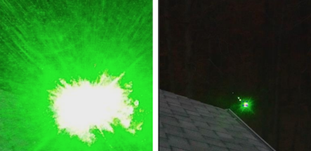
As the laser aims away from the camera, the bright center of the laser is still visible (right image, above). The system then looks at the center of the bright area to find the pixel location. Knowing the camera’s orientation, location and altitude, a Raspberry Pi computer running a Python program written by Hough calculates the approximate location. This is automatically sent via text message to pre-programmed recipients which could include law enforcement.
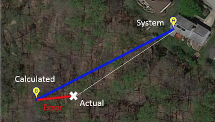
In ground testing on a slope, at a relatively short distance, the error was 15 meters. As the photo diagram shows, the system was successful in determining an approximate distance and location.
Hough notes that the system is a low-cost proof-of-concept. Suggested improvements include “more precise location sensors [that] would improve target location accuracy. Tapping into the high quality compass and GPS sensors on a commercial aircraft, for example, would drastically improve the ability of the system.” He also stated that smartphones include all the equipment needed: camera, compass, GPS, processor and display. So it should be possible to make a smartphone application to accomplish the same task.
From “Detection and Location System for Laser Interference with Aircraft”, December 2016. Thanks to Nate Hough for bringing this to our attention and allowing us to host the PDF. Note: A similar system, which does not calculate the laser source location, is the Laser Event Recorder.
US: Mobile app planned for detecting laser illuminations
LERapp was developed a few years ago by Dr. Craig Williamson of the U.K. Defence Science and Technology Laboratory (Dstl). The app uses the smartphone camera; when a laser or bright light event is detected, the app makes a digital record. This includes a picture of the event, the GPS location of the phone, the user’s heading, the date and time, and laser parameters such as the beam color and estimated irradiance. A March 2013 paper, presented by Dr. Williamson at the International Laser Safety Conference, describes the app in more detail.
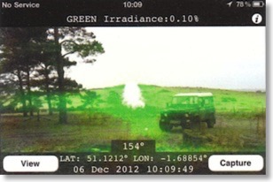
Screenshot from the 2013 version of the Laser Event Recorder app
As far as LaserPointerSafety.com can determine, the app was never made publicly available such as being put on an app store.
To commercialize LERapp, in December 2016 it was licensed to Profound Technologies, Inc. of Warner Robins, Georgia, who will be doing further development and marketing in major regions such as the U.S., U.K. and Europe. Profound’s president Randall Fitzgerald said that there are two planned versions.
One version will be a free or low-cost basic app that has the current features of LERapp. Profound will also be developing a central database where laser incident reports will be automatically filed, which then can be pushed out to other users of LERapp such as nearby pilots. These notifications would be available in a higher-cost version, or perhaps the notification feature would be a “freemium” add-on to the basic app.
The app will not directly be able to locate the laser’s location — the only geographic information stored is the GPS location and heading of the smartphone at the time of the incident. However, having a photo of the laser illumination may allow law enforcement to locate landmarks or street patterns. Also, Profound is considering future versions which could triangulate a ground location or area based on multiple illumination events reported to the database within a short timespan.
LERapp currently runs on Apple’s iOS operating system for iPhones. There is as yet no public release schedule for the basic or database versions. At the time of Apple App Store release, Profound also intends to have an Android-compatible version available.
From a Profound Technologies press release dated December 4 2016 and a December 8 telephone interview with Randall Fitzgerald. LaserPointerSafety.com previously ran a story about the Dstl version of the LERapp in March 2013.
US: $208 million contract to protect Army helicopters from laser threats
The Army/Navy Piloted Aircraft/Visual and Visible Light/Receiving, Passive Detecting (AN/AVR-2B) Laser Detecting Sets (LDS) uses four sensor units placed on the aircraft. It is smaller, lighter and uses less power than a previous generation developed for the cancelled Comanche helicopter program.
News reports did not state how much it costs to equip each helicopter with an AN/AVR-2B system.
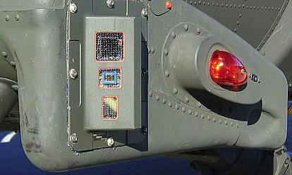
One of the four sensor packages to detect laser threats on U.S. military helicopters
From Avionics Intelligence August 31 2013 and September 3 2013
UK: Low-cost laser event recorder is an iPhone app
UK: Police "fight back" by tracking laser hits
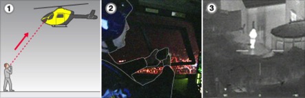
1: Police helicopter is targeted by laser pointer on the ground. 2: Helicopter crew use Laser Event Recorder to locate pointer via GPS, and record its wavelength. 3: GPS details enable helicopter’s thermal (infrared) camera to find suspect, and send police patrol on the ground to arrest the person.
In addition, the UK’s Civil Aviation Authority is planning new laws prohibiting shining a laser at an aircraft. Currently, prosecutors have to prove that the laser user “recklessly or negligently endangered an aircraft”.”
BBC quotes Bob Jones, head of flight operations at the CAA: “"To those individuals targeting aircraft with laser devices the message is clear -- don't. You will be caught and you will be prosecuted and you could spend up to five years in prison. These things are not toys, they pose a serious risk to all flight safety."
Many more details, including photos and a video of a helicopter finding a laser perpetrator, are at the BBC News website.